By Jim Stefkovich, Meteorologist, Alabama Emergency Management Agency
CLANTON – Monday, 730 am, July 27, 2026
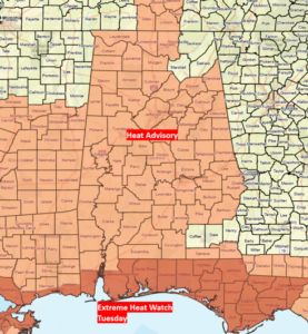
…Extreme Heat Watch Tuesday Mobile and Baldwin Counties…
…Heat Advisories for parts of state today and especially Tuesday…
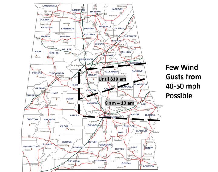
At 730 am, a cluster of south of I-20 and generally east of I-65 will continue southward this morning with very heavy rainfall and a few wind gusts from 40-50 mph possible through 10 am before the storms are forecast to weaken.
As I mentioned in yesterday’s briefing, we are in a northwest flow aloft pattern, with upper level disturbances and relatively small Mesoscale Convective Systems (MCS) moving from northwest to southeast through Wednesday. These small systems are difficult to pinpoint both in time and exact location more than 12 hours in advance. Another MCS may move through the state later today, with
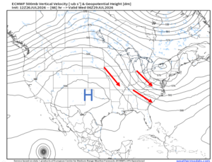
To discuss precipitation this week, look at the last graphic below, which shows upper level winds (red arrows) and a large area of high pressure centered across Texas and New Mexico, valid Tuesday night.
There’s an old weather saying, “Big High, it’s dry”. During the summer, large domes of high pressure keep surface temperatures hot with little rainfall. Just to the east of this High pressure, some models are showing the southeastern US under a northwest flow aloft regime this week. Upper level disturbances move from northwest to southeast in this flow and form Mesoscale Convective Systems (MCS). Depending on their strength, they can produce severe weather day or night.
Some models are indicating Alabama will stay in the northwest flow aloft this week, which could lead to periodic episodes of MCS development and the potential for severe weather. However, there are also indications that the high pressure area will shift eastward. If this happens, Alabama would have fewer chances of MCS activity, as they would also shift eastward of our state.
This is something to watch over the next few days.
Afternoon Heat Index values today and Tuesday will generally be 105-110 and as high as 115 near the coast. Heat Advisories will likely be expanded into Wednesday in later updates.