By Jim Stefkovich, Meteorologist, Alabama Emergency Management Agency
CLANTON –Friday 1100 am, October 9, 2026
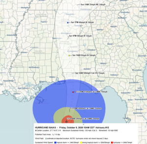
As of 10 am, Isaias is now a Category 3 major hurricane with sustained winds of 120 mph. Hurricane-force-winds extend 35 miles outward from the center with tropical-storm-force winds extending 210 miles from the center. Gusts to 35 mph (just below tropical-storm-force winds) were reported at 9 am in Pensacola.
A small shift eastward shift for the track forecast has occurred since early this morning, but timing has not. Landfall is still forecast between 9 pm and midnight between Pensacola and Santa Rosa Beach, Florida as a Major Hurricane with sustained winds of 115 mph and higher gusts.
Isaias will remain a hurricane into south-central Alabama and a tropical storm through most of the state until it exits Alabama Saturday evening.
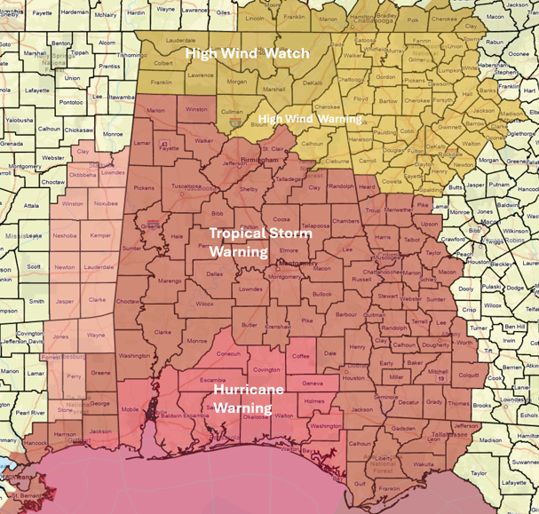
Widespread damage and power outages are likely. The Hurricane Warning has been expanded in southern Alabama, with a Tropical Storm Warning near the I-20/I-22 corridor, and a High Wind Warning into central Alabama, with a High Wind Warning from I-20 to the I-59 area.
All actions to protect property should be complete near the coast, by mid-afternoon in the south-central sections, and by 10 pm elsewhere across the state.
A full briefing will be provided after the 4 pm NHC update.