
By Jim Stefkovich, Meteorologist, Alabama Emergency Management Agency
CLANTON – Monday, 3:00 pm, May 4, 2026
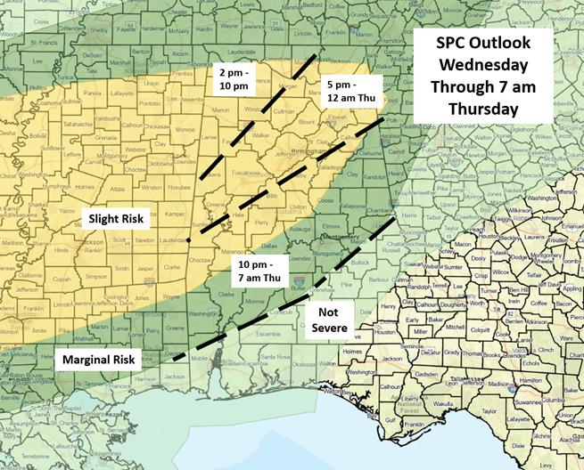
With this afternoon’s update, an earlier start time for potential severe weather and a small eastward extension of the Slight Risk have been added for Wednesday. Otherwise, there are no major changes to the forecast since this morning.
Models are coming into better agreement that line segments, and possibly some supercells, will enter northwestern Alabama on Wednesday afternoon and move southeastward into Thursday morning. The storms are expected to weaken once reaching the southern half of the state.
Very heavy rainfall, damaging straight-line winds, and a couple of tornadoes are all possible. If more supercells develop ahead of the line segments, the tornado threat would increase.
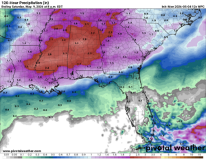
The good news is that an additional 1-3 inches of widespread rainfall will occur with locally higher amounts in stronger storms, which could lead to localized flooding.
——————————————————-
CLANTON – Monday, 6:00 am, May 4, 2026
A Marginal to Slight Risk is in effect for much of the state from Wednesday into Thursday. Models are still somewhat in disagreement about the extent of instability and timing for this system, so expect changes in later updates.
The most likely scenario is for thunderstorm line segments to enter the northwestern sections of the state late Wednesday afternoon or early evening and move southeastward overnight. Very heavy rainfall, damaging straight-line winds, and a couple of tornadoes are all possible. In addition, it is also unclear whether a few supercells can develop ahead of the line(s) of storms. If so, there would be an increase in the tornado threat.
Finally, although the main upper-level support will be moving away from the state Thursday morning, the severe and heavy rainfall threats could continue across southern Alabama from Thursday morning into the afternoon.
The good news is that an additional 1-3 inches of widespread rainfall will occur with locally higher amounts in stronger storms, which could lead to localized flooding.