
CLANTON – Wednesday, 300 pm, April 29, 2026
A Severe Thunderstorm Watch is in effect until 9 pm for portions of west-central and southwest Alabama.
A frontal boundary south of a Tuscaloosa – Montgomery – Eufaula line, combined with high instability, will lead to a few storms that could produce damaging wind gusts and hail this afternoon. Very heavy rainfall could also produce localized flooding.
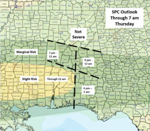
In addition, another cluster of storms will move across that state from late afternoon through Thursday morning. A few storms near and south of I-20 could produce additional heavy rainfall, a few damaging wind gusts, and hail through late tonight. The tornado threat is very low.
The timing graphic below accounts for both the ongoing storms and the approach of the additional cluster.