
By Jim Stefkovich, Meteorologist, Alabama Emergency Management Agency
CLANTON – Tuesday, 1:00 pm, April 28, 2026
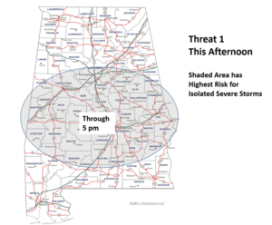
Storms near and south of I-20 will continue to redevelop this afternoon with very heavy rainfall, a few wind gusts from 40-60 mph, and hail up to quarter size being the main threats.
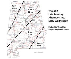
A Mesoscale Convective System (MCS) or large cluster of storms in Arkansas and northern Louisiana at 12:30 pm will reach western Alabama late this afternoon or evening and move eastward through early Wednesday morning. Damaging wind gusts, hail, and very heavy rainfall are the main threats. In addition, a couple of tornadoes are also possible, mainly across the western half of the state. There could be pockets of widespread damaging wind gusts with this cluster as it moves through Alabama.
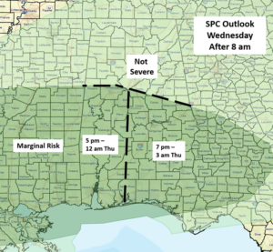
Yet another cluster of storms is forecast to move from west to east across the state Wednesday afternoon into early Thursday. There are still questions as to whether the atmosphere will recover from today’s/tonight’s activity to support severe storms, but at least a Marginal Risk is currently forecast for the potential of a few damaging wind gusts and hail as the main threats.
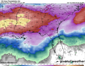
The unsettled weather pattern continues from Thursday into Saturday with additional upper-level disturbances producing rainfall at times, mainly across the southern half of the state. Total rainfall through this weekend will be 2-4 inches, but a number of locations will likely receive higher amounts. Localized flooding is possible at times beginning this afternoon through the remainder of the week.