
By Jim Stefkovich, Meteorologist, Alabama Emergency Management Agency
CLANTON – Tuesday, 7:00 am, March 10, 2026
Monday’s storms brought damaging wind gusts, widespread 1-2 inches of rainfall, with isolated three-inch amounts resulting in flooding across the northern half of the state. Scattered showers and a few thunderstorms are possible today, generally north of I-20. A couple of storms could produce wind gusts up to 40 mph, but severe weather is not expected.
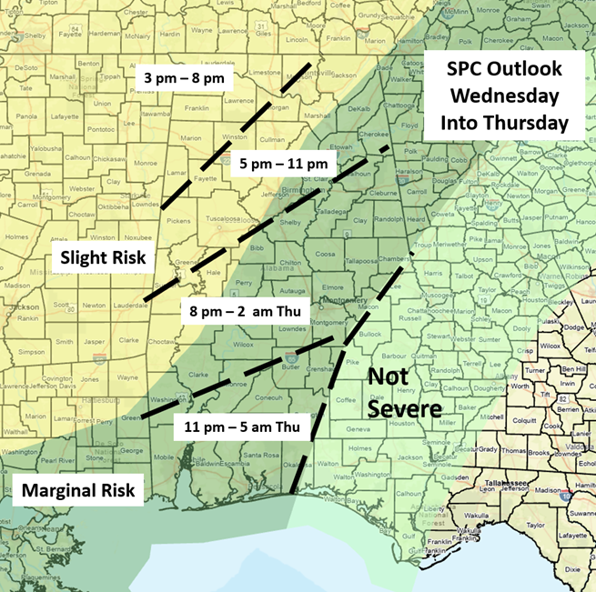
Models continue to indicate a line of thunderstorms entering northwestern Alabama on Wednesday afternoon and moving southward into early Thursday. The highest threat area is across the western and northern portions. Damaging wind gusts, heavy rainfall, and perhaps a tornado or two are all possible. Due to yesterday’s heavy rainfall, it won’t take much to trigger flooding across the northern half of the state.
The line of storms will weaken quickly after sunset with the loss of surface heating. There is one caveat to tomorrow’s event. It is unclear whether storms will develop ahead of the line. If so, there will be an increased severe weather threat/tornado potential.
Much colder temperatures will occur on Thursday, with highs from the 50s north to near 70 south. Lows Friday morning will range from the middle 30s north to middle 40s south. Frost is possible in some northern areas.
Finally, another upper-level system will produce showers and thunderstorms sometime from late Sunday afternoon through early Monday. This could provide a low-end severe weather threat, but confidence is low at this point.