
By Jim Stefkovich, Meteorologist, Alabama Emergency Management Agency
CLANTON – Thursday, 230 pm, January 29, 2026
The forecast continues to indicate only a 20% or less chance of any precipitation across the state from Friday morning through the afternoon. There could be snow flurries or light snow with no accumulation, mainly for areas north of I-20, with light rain or rain showers elsewhere.
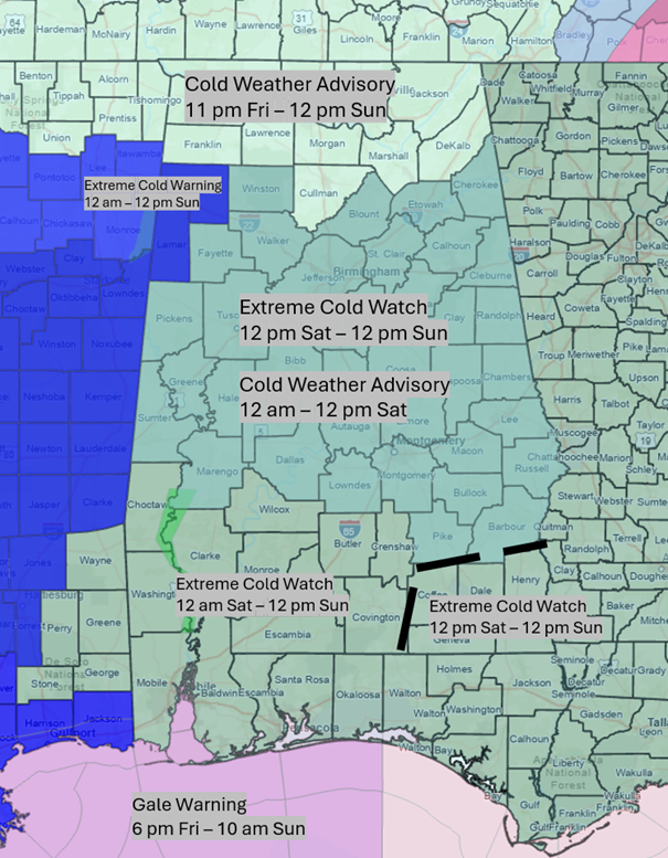
There are increasing chances that bands of snow flurries or snow showers will occur Friday night through Saturday morning, mainly across the far northern and northeastern sections of the state, but could also occur across the northern half of Alabama. At this point, accumulations are forecast to be a trace to 1/4 inch.
However, there are currently very low chances that snow bands with slightly heavier snowfall could occur north of I-20, and lake effect snow may also occur south of Wheeler Lake and Guntersville Lake on Saturday. Yes, lake effect snow DOES occur in Alabama!
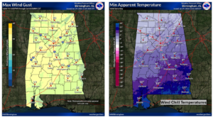
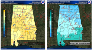
In addition to another blast of arctic air moving into the state Friday afternoon and continuing through Sunday, very gusty winds will occur. Gusts up to 30 mph are forecast Friday night into early Saturday morning, 30-40 mph Saturday morning through the afternoon, and 20-30 mph Saturday night. Many areas north of I-20 will remain below freezing from Friday evening to Monday afternoon.
The following are the forecast temperatures through Tuesday:
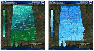
Today – Highs 40s north to 50s south. Lows Friday morning in the 20s northern half and 30s southern half.
Friday – Highs from the 30s north to middle 50s south. Lows Saturday morning around 10 degrees north with teens and 20s elsewhere. Gusty winds will produce wind chills from 0 to -5 degrees north with single digits to teens elsewhere.
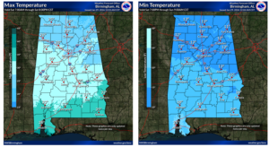
Saturday – Highs in the 20s north and central with lower to middle 30s south. Gusty winds during the day will produce wind chills in the single digits to teens north, with teens to lower 20s south. Lows Sunday morning around 10 degrees north and teens elsewhere.
Sunday – Highs mainly in the 30s. Lows Monday morning mainly in the teens to lower 20s.
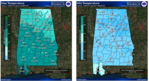
Monday – Highs mainly in the 40s with lower to middle 50s south. Lows Tuesday morning in the 20s.
Tuesday – Highs from the 40s north to upper 50s south. Lows Wednesday morning mainly in the 30s.