By Jim Stefkovich, Meteorologist, Alabama Emergency Management Agency
CLANTON – Friday, 6:00 am, May 22, 2026
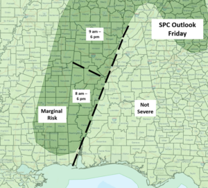
The combination of a stalled frontal boundary and an approaching upper-level disturbance this morning will lead to clusters of storms across much of western and northern Alabama today.
A few storms could produce wind gusts from 40-60 mph, and a tornado or two is also possible. In addition, storms repeatedly moving across the same areas could produce 4+ inches of rainfall, leading to some flooding, especially in urban areas.
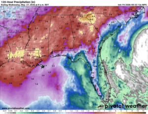
The wet pattern will continue not only through the Memorial Day weekend, but well into next week. This will bring much-needed and widespread rainfall with at least 2-4 inches through next Tuesday.
However, there will be a number of locations with 6+ inches by next week. The good news is that the rainfall will not be continuous, which should allow any flooded areas to subside day to day.
Finally, it’s important to remember that if you can hear thunder, you are likely within distance of being struck by lightning. If you are outdoors, make sure you get to a safe location until the storm passes.